Two to three days is the sweet spot for the Icefields Parkway. That gives you time to drive all 232 km of Highway 93 from Banff to Jasper, stand on the Athabasca Glacier, and still pull over for turquoise lakes and roadside waterfalls without racing the light. You can drive it in a single long day, but a road this spectacular deserves to be slowed down.
This is a stop-by-stop plan built around the real towns and lookouts along the Icefields Parkway, one of the most spectacular mountain drives on Earth. It is an easy, fully paved route through the Canadian Rockies that suits any vehicle, including EVs, so the only real planning is where to stop and when to go.
The Icefields Parkway at a glance
Highway 93 threads the spine of the Canadian Rockies, linking Banff and Jasper National Parks through a corridor of glaciers, turquoise lakes, and peaks topping 3,000 m at almost every turn. Most people picture the Columbia Icefield, but the drive is really three landscapes stitched together: the famous lakes around Lake Louise, the high glacial passes in the middle, and the waterfall canyons that lead down into Jasper.
- Distance: 232 km, Banff to Jasper
- Time needed: 1 to 3 days (2 is ideal for first-timers)
- Difficulty: easy, paved highway, any vehicle
- Best season: June to September
- EV-friendly: yes, with chargers in Banff, Lake Louise, and Jasper
A quick word of caution: this is a mountain highway with long stretches between services, sudden weather, and wildlife on the road at dawn and dusk. Carry fuel, water, and layers, and check Parks Canada road reports before you leave.
How many days do you need?
The honest answer depends on how much you want to stop. Here is what each length of trip realistically buys you.
| Trip length | What you fit | Best for |
|---|---|---|
| 1 day | Lake Louise, Peyto Lake, Columbia Icefield, Athabasca Falls, straight through to Jasper | A fast transit with the headline stops |
| 2 days | All of the above plus Moraine Lake, Bow Lake, a glacier walk, and an unhurried morning | First-timers who want the full parkway |
| 3 days | The whole corridor at a gentle pace, side hikes, and a stargazing night in Jasper | Slow travel and photographers |
A one-day blast from Banff to Jasper is the most common mistake. The middle of the parkway, around Bow Lake and Peyto Lake, holds some of the best views on the continent, and they reward the people who arrive early and linger.
Day 1: Banff, Lake Louise, and Moraine Lake
Start in Banff, the gateway town, with its hot springs, elk on the main street, and the Fairmont Banff Springs castle looming over the valley. Fuel up and stock the cooler here before heading north.
Your first essential stop is Lake Louise, the most photographed lake in Canada, its impossibly turquoise glacial water backed by the Victoria Glacier. A short drive away is Moraine Lake, where ten peaks reflect in electric-blue water so iconic it once appeared on the Canadian twenty-dollar bill. Access to Moraine Lake is tightly managed in summer, so plan ahead for the shuttle or an early arrival. These two lakes alone justify a full first day.
Day 2: Bow Lake, Peyto Lake, and the Columbia Icefield
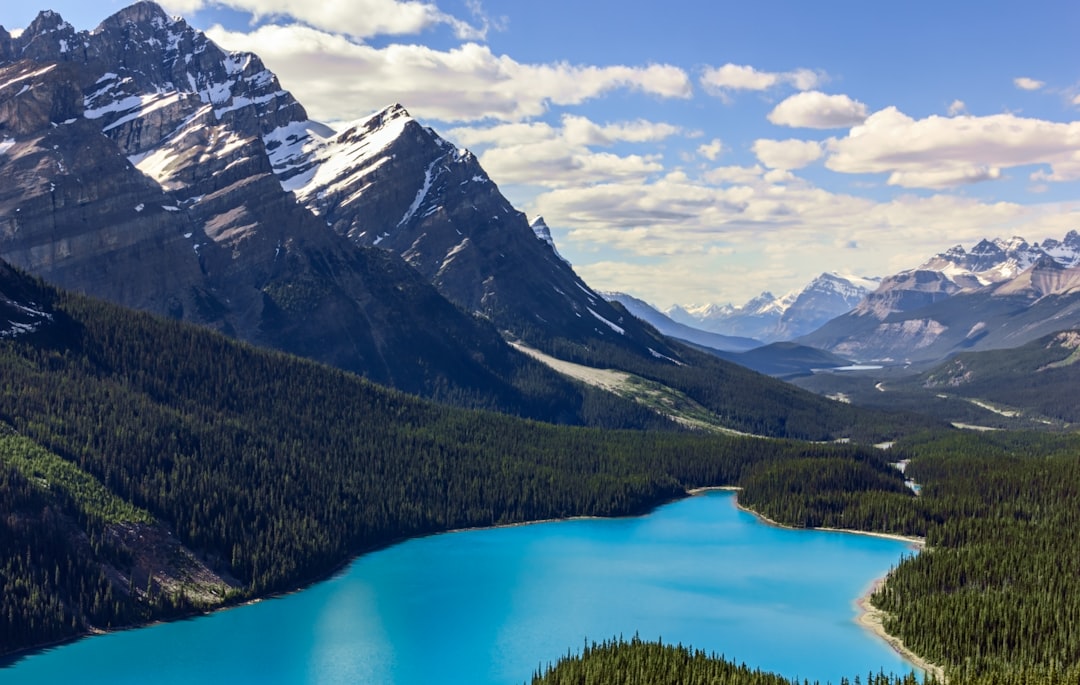
This is the big scenery day, and where the official parkway truly opens up. Pull in at Bow Lake, the serene headwaters of the Bow River, fed by the Bow Glacier on the slopes above. A little further on, climb to the Peyto Lake Viewpoint, where a wolf-shaped lake of blinding turquoise sits below the Mistaya Glacier. It is the best single viewpoint on the entire parkway, so time it for morning light before the tour buses arrive.
Midway between the parks lies Saskatchewan River Crossing, the only services between Lake Louise and Jasper, set where three glacial rivers meet in a sweeping valley. Top up your fuel here. Then comes the headline act: the Columbia Icefield, the largest icefield in the Rockies, where you can walk onto the Athabasca Glacier, one of the most accessible glaciers in the world. Stand on ancient ice that has been flowing here for thousands of years, then continue north toward Jasper as the landscape shifts from rock and ice to forest and river canyon.
Day 3: Sunwapta Falls, Athabasca Falls, and Jasper
The final stretch trades alpine passes for thundering water. Stop at Sunwapta Falls, where the Sunwapta River plunges into a narrow limestone canyon, with both an upper and lower falls worth the short walk. A bit further, Athabasca Falls is the most powerful waterfall in the Canadian Rockies. It is not the tallest, but the raw force of the water carving through the gorge is genuinely humbling.
End in Jasper, a laid-back mountain town with the darkest skies of any national park in Canada. If you have a clear night, stay up for the stargazing, often called the best on the continent. From here you can loop back south or carry on toward the rest of the Rockies.
When to drive the Icefields Parkway
The catalog season is June to September, when the passes are clear of snow and the days are long enough to fit every stop without rushing. Outside that window, expect winter closures and difficult driving, and conditions can change fast at higher passes even in summer.
Wildlife is part of the experience and part of the risk. Bighorn sheep, elk, and bears appear at the roadside, especially at dawn and dusk, so drive slowly through the dim hours and never block traffic to get a photo. Fuel up wherever you can, because the gap between services at Saskatchewan River Crossing is real.
Frequently asked questions
How many days do you need for the Icefields Parkway?
Two days is ideal. It lets you drive the full 232 km from Banff to Jasper, see Lake Louise and Moraine Lake, walk on the Athabasca Glacier, and reach the waterfalls without rushing. One day covers the headline stops if you keep moving, while three days suits slow travel, side hikes, and a stargazing night in Jasper.
Is the Icefields Parkway suitable for any car?
Yes. Highway 93 is fully paved and rated easy, so any vehicle handles it, including EVs, which can charge in Banff, Lake Louise, and Jasper. The real challenges are long gaps between services, sudden mountain weather, and wildlife on the road, not the driving itself.
When is the best time to drive the Icefields Parkway?
June to September. That is when the high passes are reliably clear of snow and daylight is long enough to fit every stop. Outside summer, expect winter closures and hazardous conditions, and always check Parks Canada road reports before you set out.
Where can you get fuel on the Icefields Parkway?
Fill up in Banff, Lake Louise, or Jasper at the ends, and use Saskatchewan River Crossing in the middle, the only services between Lake Louise and Jasper. The stretches between are long and remote, so never let the tank run low.
Can you drive the Icefields Parkway in one day?
You can, and many people do it as a transit between Banff and Jasper. But a single day means hurrying past Bow Lake, Peyto Lake, and the glacier walks that make the drive unforgettable. Give it at least two days if you possibly can.
Plan your drive
Ready to map it out? See the full Icefields Parkway route guide for every stop in order, compare it with British Columbia's Sea-to-Sky Highway or Nova Scotia's Cape Breton Cabot Trail, and build your own version on the interactive map.