A classic Pacific Coast Highway road trip runs 1,055 km along California Highway 1 from San Francisco to Santa Monica, and you want 4 to 7 days to drive it well. Four days is the brisk version. Seven days is the one you will not regret, with room for Big Sur, Hearst Castle, and an unhurried afternoon in Santa Barbara. This is the Pacific Coast Highway stop by stop, planned the way a coast this good deserves.
How many days do you need on the Pacific Coast Highway?
The drive itself is short by American road-trip standards, but Highway 1 is slow on purpose. Narrow two-lane sections, fog, and viewpoints you will actually want to stop at mean the map always underestimates your day. Here is how the common plans compare.
| Days | Pace | Best for | What you trade |
|---|---|---|---|
| 4 days | Brisk | A long weekend, drivers short on time | Hurried Big Sur, no Hearst Castle tour |
| 5 days | Comfortable | First-timers who want the highlights | Less beach time in the south |
| 7 days | Relaxed | The full coast without watching the clock | Nothing essential |
If you can only spare four days, drive it anyway. But if a week is on the table, take it. The southern beaches and the wine country detours are where a rushed trip loses its shine.
Which direction should you drive it?
Drive north to south, San Francisco to Los Angeles. In the United States you drive on the right, so heading south puts your car in the ocean-side lane. That means the pullouts and overlooks are on your side of the road, no left turns across oncoming traffic, and an unobstructed view of the cliffs the whole way down. It is the small decision that makes the biggest difference.
The 7-day Pacific Coast Highway itinerary, stop by stop
Day 1: San Francisco to Santa Cruz
Start at the Golden Gate Bridge, where fog, hills, and the Pacific greet you before you have even left the city. Roll south through Pacifica and Half Moon Bay, a quiet town known for giant pumpkins and the monster winter surf at Mavericks. Finish the day at the Santa Cruz Boardwalk, all surf culture and sea lions lounging on the wharf. Short driving day, easy start.
Day 2: Santa Cruz to Carmel
A slow, rich morning. The Monterey Bay Aquarium sits on Cannery Row with sea otters floating in the kelp forest just outside the windows. Take the afternoon for Carmel-by-the-Sea, a fairytale village with no street addresses, a white-sand beach, and Clint Eastwood as a former mayor. Just south, Point Lobos State Natural Reserve has the coves and headland trails that show you what is coming.
Day 3: Big Sur
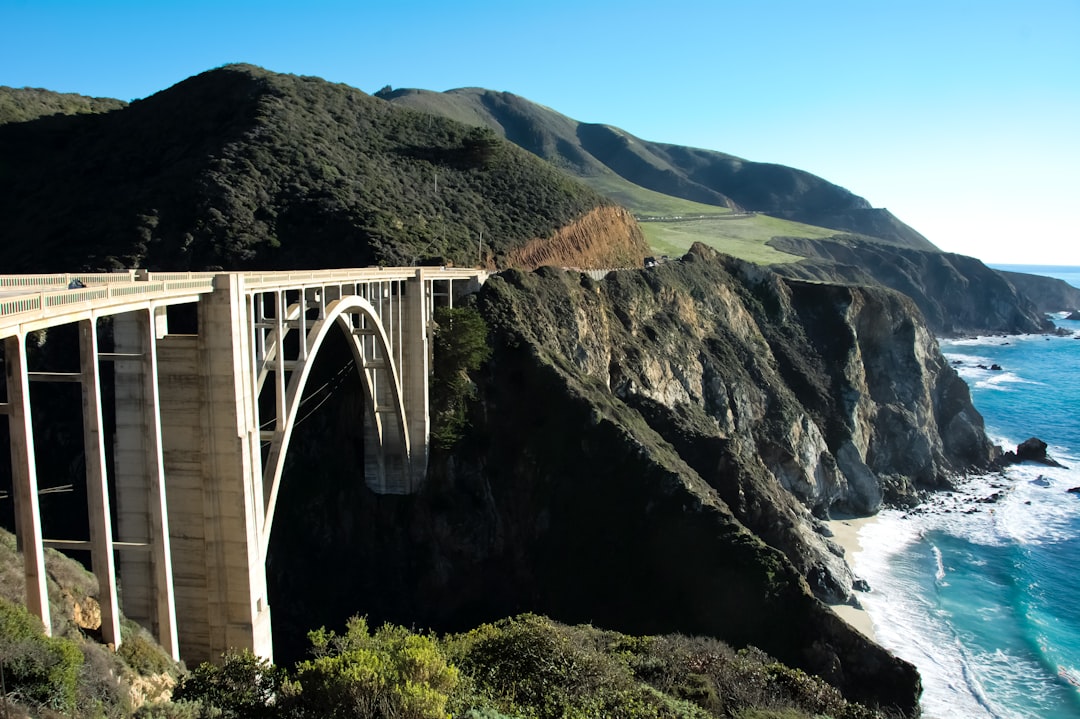
The heart of the drive. The Bixby Creek Bridge is the most photographed spot on the coast: sheer cliffs, a graceful arch, turquoise water far below. A little farther, McWay Falls drops 80 feet straight onto a hidden cove beach inside Julia Pfeiffer Burns State Park. Keep this day short on distance and long on stops. This is the stretch you came for.
Day 4: Big Sur to Morro Bay
Continue down the wild southern Big Sur coast through Lucia toward San Simeon and Hearst Castle, William Randolph Hearst's mountaintop palace with 165 rooms, three pools, and a former private zoo. Book the guided tour ahead. End the day at Morro Bay, where a 23-million-year-old volcanic plug dominates the harbor and the clam chowder is the best on the central coast.
Day 5: Morro Bay to Santa Barbara
An easy, sunny leg. Stop at Pismo Beach, then settle into Santa Barbara, the so-called American Riviera. Spanish colonial architecture, the hilltop Santa Barbara Mission known as the Queen of the Missions, wine country just inland, and near-perfect weather most of the year. This is the day to slow down.
Day 6: Santa Barbara to Malibu
A short hop down through Ventura to Malibu, 27 miles of celebrity beaches, legendary surf breaks, and the Getty Villa standing above the Pacific. Walk the Malibu Lagoon, watch the surfers, and have a long lunch on the pier.
Day 7: Malibu to Santa Monica
The grand finale is brief. Roll into the Santa Monica Pier, the Pacific, a Ferris wheel, and a golden California sunset to close the trip. It is also, fittingly, the western end of Route 66, so you finish where another great American road trip begins.
Where to eat along the Pacific Coast Highway
The food is part of the route, and a few stops are worth planning a day around.
- Nepenthe, Big Sur. A cliffside terrace with classic American fare and a panoramic ocean view that earns the prices.
- The Sardine Factory and Old Fisherman's Grotto, Monterey. Fresh seafood and famous clam chowder on Cannery Row and Fisherman's Wharf.
- The Hitching Post II, Buellton. Santa Maria-style barbecue and local Pinot, a perfect inland detour near Santa Barbara.
- Malibu Farm, Malibu. Farm-to-table plates served on the pier with the surf below you.
When to go and what to watch out for
The best seasons are summer and fall, when the coast is clearest and the roads are open. Highway 1 can close for landslides, wildfire work, or winter storm damage, especially in Big Sur and on post-fire slopes, so always check current closures before committing to a long stretch between towns. Fog and wind make the driving slower than it looks, and the gaps between fuel stops in Big Sur are real. Keep the tank topped up and never drive that section on fumes.
The road is paved, easy, and EV-friendly the whole way, so any car will do. The challenge is patience, not difficulty.
Frequently asked questions
How long does it take to drive the Pacific Coast Highway?
The San Francisco to Santa Monica route is 1,055 km and takes 4 to 7 days at a comfortable pace. You can technically drive the highway in two long days, but you would miss the entire reason to be on it.
Is the Pacific Coast Highway difficult to drive?
No. Highway 1 is fully paved, easy to follow, and suitable for any car, including EVs. The only real challenges are narrow two-lane sections, coastal fog, and occasional closures in Big Sur, all of which simply slow you down rather than make the drive hard.
Should you drive the Pacific Coast Highway north to south or south to north?
Drive north to south, from San Francisco to Los Angeles. Because the United States drives on the right, southbound keeps you in the ocean-side lane with the pullouts and the best views directly on your side of the road.
What is the best time of year for the Pacific Coast Highway?
Summer and fall are the best seasons, with the clearest skies and the most reliable road access. Winter brings the highest risk of landslide and storm closures, particularly through Big Sur.
Can you extend the Pacific Coast Highway trip further?
Yes. North of San Francisco the coast keeps going through redwood country, and across the border the Sea to Sky Highway and the Olympic Peninsula Loop carry the Pacific theme up into British Columbia and Washington.
Ready to map it out? See the full Pacific Coast Highway guide for every stop, or open the interactive map to plan your own version of the coast.